
www.aero-defence.tech
19
'26
Written on Modified on
Hyperspectral Satellite Remote Sensing for Climate Science
KBR executes mission operations and aerospace engineering for NASA's PACE satellite to deliver continuous atmospheric aerosol and ocean ecology data.
www.kbr.com
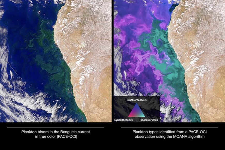
Quantifying the interactions between aerosol loading, cloud formation, and ocean biogeochemistry represents one of the most critical challenges in global climate modeling. Conventional satellite imagers typically capture broadband radiometric channels across a limited number of spectral bands, which obscures subtle variations between different atmospheric particle types—such as sea salt, sulfates, fine wildfire smoke, and mineral dust—and restricts the identification of distinct phytoplankton communities in aquatic ecosystems. Resolving these coupled ocean-atmosphere interactions requires orbital hyperspectral imaging radiometers paired with multi-angle polarimeters, sustained by contamination-controlled satellite integration and continuous mission telemetry operations.
Instrumentation Engineering and Optical Payloads
To capture these atmospheric and marine dynamics, KBR delivered specialized systems engineering and integration services for NASA's Plankton, Aerosol, Cloud, ocean Ecosystem (PACE) mission. KBR teams contributed to the development and hardware assembly of PACE's primary sensor, the Ocean Color Instrument, alongside the mission's advanced multi-angle polarimeter suite, which includes the Hyper-Angular Rainbow Polarimeter (HARP2) and the Spectro-polarimeter for Planetary Exploration (SPEXone).
The Ocean Color Instrument utilizes an optical spectrometer to measure subtle radiance shifts across ultraviolet, visible, and infrared wavelengths. Operating across continuous spectral bands from 340 nm to 895 nm alongside shortwave infrared channels, the sensor captures spectral signatures that distinguish discrete aerosol species and identify early stages of harmful algal blooms in marine and freshwater bodies before standard optical channels detect water discoloration.
Contamination Control, Integration, and Ground Support
Because spaceborne optical radiometers and polarimeters degrade rapidly under microscopic hydrocarbon outgassing and particulate accumulation, KBR executed the spacecraft's mechanical engineering protocols and cleanroom contamination control procedures throughout payload integration. Engineering teams supported structural assembly, vibration qualification, and environmental vacuum testing for all payload instruments and the core satellite bus.
During launch operations conducted at Cape Canaveral Space Force Station in Florida, KBR personnel provided on-site ground support and launch-site engineering during the spacecraft's launch into Sun-synchronous orbit in February 2024. Following vehicle separation and orbit insertion, the team transitioned to sustaining engineering support, overseeing orbital subsystem health during early checkout phases.
Orbital Mission Operations and Data Pipelines
KBR performs full-lifecycle mission operations for the PACE spacecraft from dedicated ground control facilities. Flight operations teams manage real-time commanding, track spacecraft attitude, oversee propulsion and orbital station-keeping, and supervise downlinked telemetry streams.
By managing continuous data ingestion, processing, and distribution pipelines, the operational framework provides climate scientists with uninterrupted data flows. This telemetry underpins regional air quality forecasts, tracks transcontinental aerosol plume migration, and supports global marine biosphere monitoring.
Additional Context
This section details technical specifications and competitive benchmarking not included in the original product announcement.
Operating at an orbital altitude of approximately 676.5 kilometers with an inclination of 98 degrees, the PACE observatory completes a global revisit cycle every two days. The Ocean Color Instrument features a rotating cross-track telescope providing a swath width of approximately 2,660 kilometers with a 1-kilometer spatial resolution at nadir. Continuous spectral coverage spans from 315 nm in the ultraviolet to 895 nm in the near-infrared at 5 nm spectral resolution (2.5 nm sampling), complemented by seven discrete shortwave infrared bands centered between 940 nm and 2,260 nm. The payload's rotating telescope incorporates a tilt mechanism up to 20 degrees to suppress sea-surface sun glint, a common artifact in ocean color radiometry.
In satellite-based Earth observation benchmarking, PACE's hyperspectral radiometer bridges the observational architectures of legacy multispectral platforms, such as NASA's MODIS (Moderate Resolution Imaging Spectroradiometer aboard Terra/Aqua) and the VIIRS (Visible Infrared Imaging Radiometer Suite aboard NOAA-20/Suomi NPP), which rely on wide, discrete spectral bands typically spaced 20 to 50 nm apart. By combining continuous 5 nm hyperspectral resolution with the multi-angle polarimetry of HARP2 (up to 60 viewing angles) and SPEXone (five viewing angles measuring degree of linear polarization to within 0.003), PACE enables multi-modal aerosol characterization. This configuration separates Rayleigh scattering from aerosol optical depth and resolves microphysical cloud droplet properties, establishing a modern benchmark for orbital ocean ecology and aerosol-cloud-radiation coupling.
Edited by Romila DSilva, Induportals Editor, with AI assistance.
www.kbr.com
