
www.aero-defence.tech
06
'26
Written on Modified on
Archer’s ZEE AI Foundation Model Achieves Frontier Breakthrough for Aviation Safety
In July, Archer announced ZEE to deliver a unified aviation intelligence platform built on ADS-B, ATC communication, maps, aircraft state, terrain and weather data.
www.archer.com
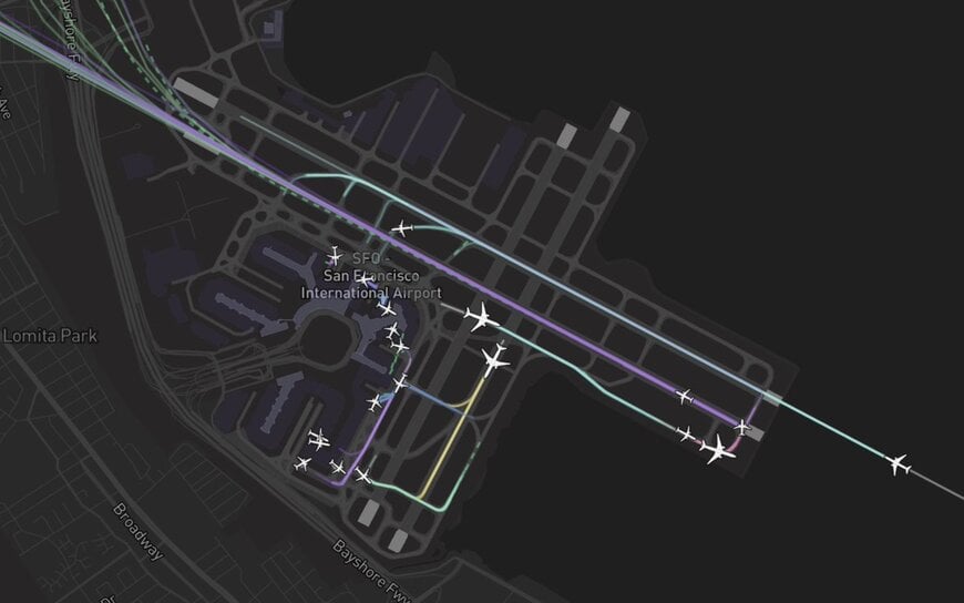
Archer has introduced ZEE, an aviation foundation model designed to predict real-time aircraft trajectories on airport surfaces several minutes in advance. The technology combines generative conditional flow matching with vision transformers to enhance situational awareness for air traffic controllers and flight crews.
Air Traffic Management and Safety Challenges
Air traffic controllers and flight crews manage more than 44,000 daily flights across the National Airspace System. While airspace modernization efforts frequently target flight congestion, runway-related incidents account for 30% to 40% of global aviation accidents. Meeting airspace demand requires artificial intelligence systems capable of processing real-time data to extend situational awareness for pilots and air traffic controllers.
ZEE is engineered to transition air traffic management from passive data aggregation to an active predictive system, establishing a safety framework for airport surface operations. Mario Srouji, VP of AI Products at Archer, stated that ZEE converts raw observations into predictive context to identify path anomalies and cross-route conflicts before safety risks develop, providing operational personnel with additional response time.
Generative Framework and Vision Transformer Architecture
Traditional prediction models encounter operational limitations when predicting fluid, branching choices made by aircraft on the ground. To address this, ZEE incorporates a generative framework based on conditional flow matching, which models the full distribution of possible trajectory paths rather than predicting a single deterministic route.
This generative framework is paired with a vision transformer trained on high-resolution satellite imagery. The vision transformer identifies native map features, including runways, taxiways, and aprons, grounding the model's spatial calculations and trajectory predictions in physical geospatial data.
Field Testing and Regulatory Collaboration
Initial field testing of the ZEE platform has been initiated at Hawthorne Airport, a facility acquired by Archer. Early performance evaluations comparing predictions against real-world tracking data demonstrate high accuracy, and larger-scale testing is currently underway.
To integrate the technology into the broader aviation ecosystem, Archer plans to collaborate with government agencies to build the empirical data foundation required to validate ZEE as a predictive safety layer supporting air traffic controllers and pilots worldwide.
Additional Context
This section details technical specifications not included in the original news release.
Conditional Flow Matching (CFM) is a generative modeling methodology that learns continuous-time vector fields to transform a simple prior probability distribution into a complex target distribution. In trajectory prediction, traditional deterministic models generate a single vector output, failing to capture multi-modal operational choices such as alternative taxiway turns or hold-short decisions. CFM models the complete conditional distribution of future states by solving ordinary differential equations (ODEs), allowing the network to output probabilistic ensembles of plausible future trajectories and quantify spatial uncertainty across time horizons.
Vision Transformers (ViTs) process spatial imagery by segmenting two-dimensional visual inputs into discrete patches and mapping them as token sequences into multi-head self-attention layers. When applied to high-resolution satellite imagery of airfield infrastructure, ViTs extract global topological relationships and localized surface boundaries across runways, taxiways, and aprons. Integrating these vision-based spatial embeddings directly into trajectory prediction networks provides semantic map constraints, ensuring generated spatial paths conform strictly to navigable pavement geometry and physical airport surface boundaries.
Edited by Romila DSilva, Induportals Editor, with AI assistance.
www.archer.com
